Article | December 2024
2024 North Atlantic hurricane season: the year in review
The season brought not only a high level of storm activity but also provided a revealing look at how changing climate factors are reshaping our understanding of risk, loss projections, and storm preparedness, according to Allianz Commercial’s catastrophe risk research team.
Season summary
The 2024 North Atlantic hurricane season was characterized by unusually warm ocean temperatures, powerful atmospheric conditions, and an evolving El Niño event, which together fuelled a series of intense storms. These hurricanes posed significant challenges across the Caribbean, Gulf Coast, and the Eastern Seaboard of the US, leaving lasting impacts on infrastructure, communities, and natural landscapes.
There was an extremely fast start to the season, with Hurricane Beryl in July becoming the earliest Category 5 hurricane in the Atlantic on record. After an unusual four week pause between August and September, the season resumed to bring two other major hurricanes: Helene and Milton. As of November 25, the season had seen 18 named storms, out of which 11 became hurricanes and five became major hurricanes. Five of the 11 hurricanes made landfall in the US.
Comparing storms to pre- and mid-season forecasts and 2023 actuals
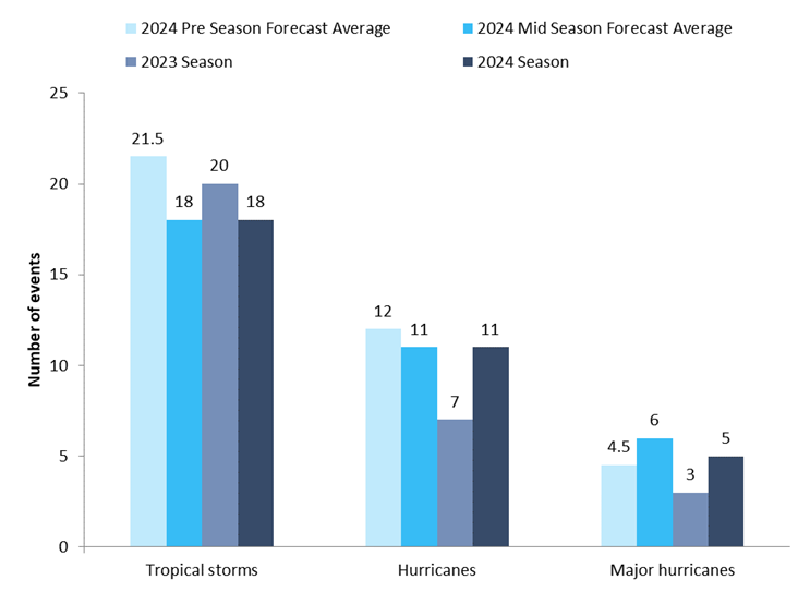
Comparison of the 2024 North Atlantic hurricane season storms to the pre- and mid- season forecast averages of AccuWeather, Colorado State University (CSU), Tropical Storm Risk (TSR), National Oceanic and Atmospheric Administration (NOAA) and North Carolina State University (NCSU) and 2023 season actuals.
Storm and hurricane landfalls
in the US
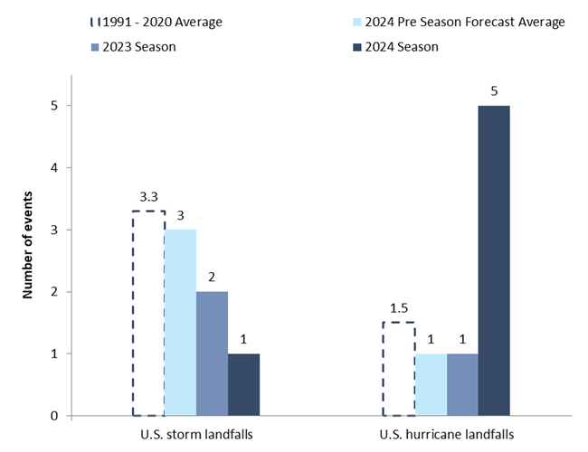
Source data: National Hurricane Center. Graphics by Allianz Commercial
Why was there such a long pause between storms?
Francine was the first storm to form after a pause of four weeks at the peak of the hurricane season. But what caused this pause, the lengthiest since 1968? In short, unexpected weather patterns reduced the effects of warm ocean temperatures and favourable winds that should have fuelled hurricane activity. Below, we explore some of these patterns.
1) Northward-shifted monsoon: during a “normal” season, the monsoon generates clusters of thunderstorms over Africa, which emerge over the Atlantic Ocean and become the “seed” for tropical storms and hurricanes. However, this year the monsoon trough took a rare path further north, over the Sahara Desert.
As a result, the thunderstorms that made it to the Atlantic, did not meet the usual warm sea surface temperatures (SSTs) that would have fueled their development into tropical cyclones. Instead, they emerged further north in an area with cooler SSTs, which hindered their development.
As a side note, the shifted monsoon brought strong rains and even flooding to the Sahara region.
2) Extremely dry, dusty air: moisture-rich air is essential for tropical cyclones to form. When thunderstorms were able to emerge over the Atlantic Ocean, they encountered an abundance of dry, dusty Saharan air across the Atlantic which supressed their development into an organized system.
3) Delayed La Niña conditions: pre-season forecasts expected that La Niña conditions would fully develop during the peak of the hurricane season, leading to a decrease in the vertical wind shear. Milder upper-level winds would have favored hurricane formation in the Atlantic basin. However, by late October neutral El Niño conditions were still present.
4) Stable upper atmosphere: extremely warm temperatures in the upper levels of the atmosphere in the tropics created more stable atmospheric conditions, making it more difficult for thunderstorms to develop and organize into a tropical cyclone.
Deep dive: Hurricane Helene
Some hurricanes are notorious for their destructive winds or intense rainfall, others for their coastal inundation. Helene brought extreme levels of all three hazards across several US southeastern states. Additionally, with a diameter of 670 km (420 mi), Helene was the third largest storm to strike the Gulf Coast since 1988, surpassed only by Opal (1995) and Irma (2017). Although a larger size does not necessarily indicate greater strength, it does imply that a larger area is exposed to the storm’s hazards.
Helene made landfall in the US as a Category 4 storm in the Big Bend area of the Florida Gulf coast late in the evening of September 26. At landfall, the system had maximum sustained wind speeds of 225 km/h and a central pressure of 938 hPa (the ninth lowest for hurricanes making landfall in Florida [1]).
Pressure is another way to measure a hurricane’s strength: typically, the lower the pressure, the stronger the hurricane. Northern Florida and southern Georgia experienced the strongest winds; however, Helene’s fast forward speed after landfall (around 48 km/h or 30 mph) and its large size allowed its damaging winds to reach far inland. As a result, regions of Georgia and South Carolina experienced considerable wind damage. These regions are rarely exposed to such strong winds, and therefore built to lower construction code requirements.
Florida’s Big Bend and the west coast of the Florida Peninsula suffered devastating storm surge of up to 4.5 m (15 ft), making it one of the highest storm surges on record in the region (with records dating back to the mid-1800s) [2]. However, the most severe impacts from Helene were felt across the southern Appalachians, where widespread, unprecedented flooding occurred, resulting in hundreds of fatalities and billions in property damage. Driven by the high sea surface temperatures (SST) in the Gulf of Mexico, Helene drew large amounts of moisture from the sea which was then released as rain as the storm moved inland. Particularly in the southern and central Appalachians, prior rains had saturated the ground and swollen the rivers, compounding to the storm’s impact and aggravating the flood. The French Broad River at Asheville (North Carolina) reached a level of 7.52 m (24.67 ft), breaking the 1916 record of 6.70 m (22 ft). The National Weather Service reported that Upstate South Carolina received 200 to 610 mm (8 to 24 in) of rain, while Atlanta received 285 mm (11.2 in) in a 48-hour period, setting a record [2].
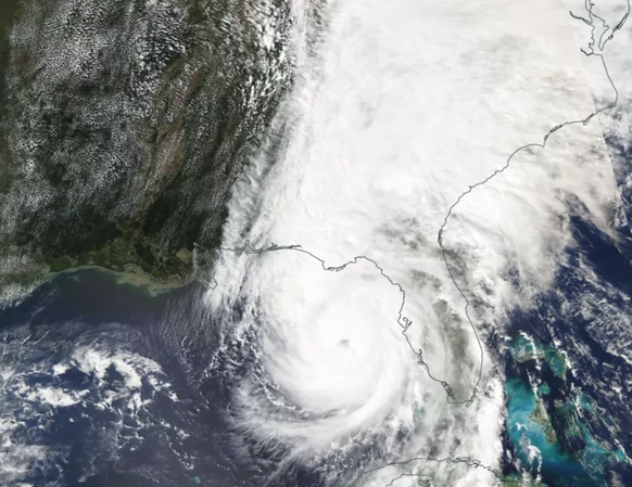
Hurricane Helene off the coast of Florida. Source: NASA Applied Sciences: "Hurricane Helene 2024."
Moody’s RMS estimates US private insured losses from Helene to range between US$8bn and $14bn, with a best estimate of $11bn. These losses are primarily driven by wind, with a higher contribution coming from Georgia than Florida. Additionally, storm surge in Florida and floods in North Carolina will account for a significant portion of this loss [3].
On the other hand, an initial estimate from the U.S. Federal Emergency Management Agency (FEMA) has placed the losses under the National Flood Insurance Program (NFIP) between $3.5bn and $7bn, largely due to storm surge in Florida, as take-up rates in North Carolina are minimal [4].
Deep dive: Hurricane Milton
If Helene will be remembered for its extreme winds, surge and flooding, Milton will go into the record books for its fast intensification: it became the fastest Atlantic storm to intensify from a tropical depression to a Category 5 hurricane, with maximum sustained winds increasing from 56 km/h to 256 km/h (35 mph to 160 mph) in just over 48 hours [5].
Milton made landfall as a Category 3 major hurricane near Siesta Key in Sarasota County, Florida on October 9, only a couple of weeks after Helene had affected many of the same areas. At landfall, it had maximum sustained winds of 195 km/h (120 mph) and a minimum central pressure of 954 hPa. As it crossed the Florida Peninsula, it brought widespread wind, storm surge, and flood to central and southern Florida. In addition, the outer rainbands of Milton produced several damaging tornadoes over southern Florida. Mandatory evacuation zones were in place with more than 5.5 million people urged to leave western Florida, the largest evacuation since Irma. 24 fatalities were reported. Flooding was also recorded in Yucatán (Mexico), the Bahamas and Cuba.
In a 24-hour period between October 6 and October 7, Milton rapidly intensified from Category 1, with maximum sustained winds of 130 km/h (80 mph) to a Category 5, with maximum sustained winds of 280 km/h (175 mph). Rapid intensification is defined as a 56 km/h (35 mph) increase in wind speed in 24 hours. Such an explosive intensification has only been exceeded by Wilma (2005) and Felix (2007). Based on wind speed, Milton became the strongest hurricane in the Gulf of Mexico since Rita (2005). Based on pressure, Milton was the fifth most intense hurricane in the Atlantic basin on record [6].
Moody’s RMS estimates US private insured losses from Milton to range between $22bn and $36bn, with a best estimate of $26bn. Additionally, losses to the NFIP could exceed $3bn [7].
Conclusion: Navigating the future of hurricanes in a changing climate
“As the 2024 North Atlantic hurricane season draws to a close, it has undeniably reshaped our understanding of storm dynamics and risk management,” says Mabé Villar Vega, Catastrophe Risk Research Analyst at Allianz Commercial. “While it introduced new challenges and highlighted the growing significance of secondary perils, it also confirmed existing trends that meteorologists have long observed, such as rapid intensifications and the increasing impact of heavy rainfall and flooding. The long calm period in the season raised questions about its implications, but this season served to reinforce the complexities of hurricane behaviour and climate interactions.
“With five hurricanes making landfall in the US, including two major storms causing billions in damages, the season highlighted the severe impacts of strong winds, storm surges and the growing threat of inland flooding.
Over the past decade, heavy rainfall and the associated flooding have emerged as one of the most deadly and costly aspects of hurricanes, emphasizing the need to prioritize these secondary perils in risk assessment and planning.”
“The rise of extreme storm events calls for innovative risk transfer methods, access to alternative capital sources and the implementation of resilience measures to enhance preparedness for future events,” adds Keerthy Mohandas, Catastrophe Risk Research Analyst, Allianz Commercial. “By learning from the experiences of this season and adapting to evolving risks, we can better prepare for future events, maintain financial stability, and safeguard lives and infrastructure.”
Sources
[1] Wikipedia: "Hurricane Helene"
[2] University of South Carolina: USC News & Events: "How Hurricane Helene became a deadly disaster across 6 states"
[3] Moody's RMS: "Moody's RMS Event Response Estimates U.S. Private Market Insured Losses for Hurricane Helene to be between US$8 Billion and US$14 Billion"
[4] Reinsurance News: "FEMA pegs NFIP losses from hurricane Helene at $3.5bn to $7bn."
[5] NASA Global Precipitation Measurement Mission: "Powerful Hurricane Milton Forms in the Gulf of Mexico, Sweeps into Florida."
[6] NOAA Climate.gov: "Hurricane Milton rapidly intensifies into Category 5 hurricane, becoming the Gulf's strongest late-season storm on record."
[7] Moody's RMS: "Moody’s RMS Event Response Estimates Private Market Insured Losses for Hurricane Milton to be between US$22 Billion and US$36 Billion."
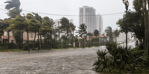
Stage picture: Adobe Stock


All the latest news, reports and hot topics


Sign up to the newsletter
Keep up to date on all news and insights from Allianz Commercial