Atlantic hurricanes 2024: businesses should brace for an active season

Expert risk article | June 2024

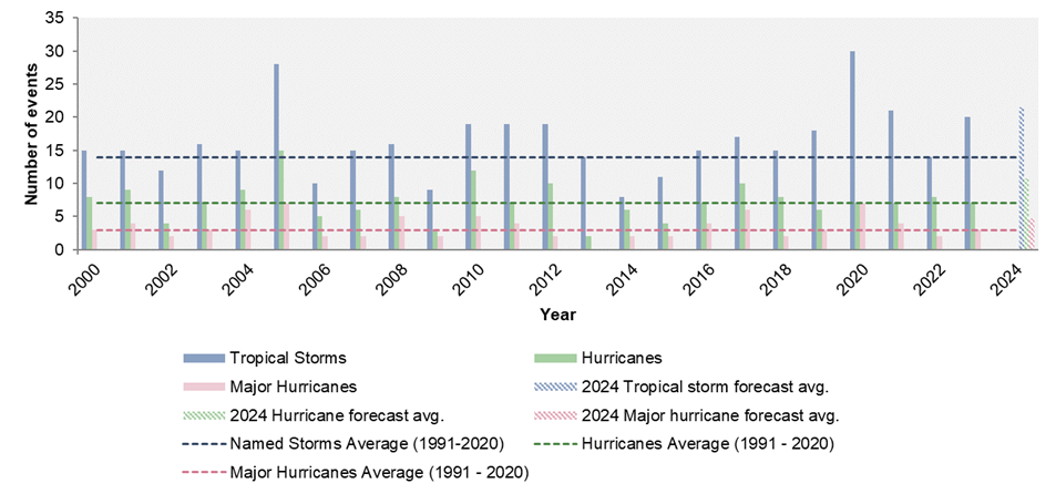
The 2024 Atlantic hurricane season officially started on June 1 and lasts until November 30, with many forecasters predicting a particularly active season. Here, Allianz Commercial looks at what could be on the horizon for 2024 and reviews the notable storm events from last year, combining insights from leading forecasting institutes with the expertise of its in-house catastrophe risk team.

With such an active season likely ahead of us, storm preparedness is a must, so don’t miss our experts’ five key steps to boosting your storm resilience. 

  • Based on forecasts, the 2024 Atlantic hurricane season is expected to be well above the 1991-2020 average, with 15 to 28 tropical storms, eight to 16 hurricanes, and two to seven major hurricanes.
  • Although 2023 was an above-average season, only eight storms made landfall, with most of the storms being referred to as ‘fish storms’ – those that stay out at sea and pose no direct threat to land.
  • Businesses can boost storm resilience by updating and testing emergency preparedness and business continuity plans, reviewing their insurance policy, and making improvements to their premises to better withstand high winds and flooding.

Early forecasts from experts at AccuWeather, Colorado State University (CSU), National Oceanic and Atmospheric Administration (NOAA), North Carolina State University (NCSU), Tropical Storm Risk (TSR), and the UK Met Office all point towards an exceptionally active 2024 Atlantic hurricane season. Unusually warm sea surface temperatures (SSTs) in the tropical Atlantic, coupled with La Niña conditions (see panel) expected to develop this summer, are creating prime favorable conditions for the development of tropical cyclones in the Atlantic.

The table below summarizes the predicted number of tropical storm events for 2024 by these six organizations. Based on their forecasts, the 2024 season is expected to be well above the 1991-2020 average, with 15 to 28 tropical storms, eight to 16 hurricanes, and two to seven major hurricanes. The NOAA has issued its highest-ever pre-season forecast. While there is high confidence the 2024 Atlantic hurricane season will be very active, uncertainties remain around factors like the El Niño Southern Oscillation, or ENSO (see panel), and outbreaks of dry, dusty Saharan air, among other factors. [1] [2]

Swipe to view more

Source*
Forecast publish date
Tropical storms**
Hurricanes**
Major hurricanes**
US storm landfalls
US hurricane landfalls
Rating
NOAA (long-term norm 1991 - 2020)   14 7 3 3.3 1.5 Long-term normal
AccuWeather* March 27 20-25 8-12 4-7 4-6 --- Above average
CSU* April 4 23 11 5 --- --- Extremely active
TSR* May 30 24 12 6 5 3 Hyperactive season
NOAA* May 23 17-25 8-13 4-7 --- --- Above normal
NCSU* April 16 15-20 10-12 3-4 --- --- Active
UK Met Office* May 22 16-28 8-16 2-6 --- --- Above average
2024 forecast range   15-28 8-16 2-7 4-6 3 Above average
Comparison: 2023 hurricane season forecast (average)   14 7 3 3 1 Average
Comparison: 2023 hurricane season (actual)   20 7 3 3 1 Slightly above average
*AccuWeather = AccuWeather Inc. forecasting service, CSU = Colorado State University, TSR = Tropical Storm Risk, NOAA = National Oceanic and Atmospheric Administration, NCSU = North Carolina State University, UK Met Office = UK Meteorological Office
**Tropical storm: > 39mph (> 63km/h); Hurricane: > 74mph (> 119km/h); Major hurricane: Categories 3-5, > 111mph (> 178km/h).

Wind shear and SSTs are two driving conditions for the formation of hurricanes. Wind shear is a measure of how much wind speed and direction vary with height. The total vertical wind shear is affected by ENSO. As of April 2024, the tropical Pacific is characterized by El Niño conditions. However, by the peak of the Atlantic hurricane season (August to October), it is expected these conditions will have shifted to La Niña, which typically means a decrease in the vertical wind shear. With milder upper-level winds, hurricane formation in the Atlantic basin is favored.

For a cyclone to form, SSTs need to be above 26°C. This year’s SSTs in the tropical Atlantic are much warmer than normal, which is expected to favor the formation of hurricanes. As of mid-May 2024, the SSTs in the North Atlantic are as high as the average SSTs (1982-2011) by mid-June. Most Atlantic SSTs registered in 2024 have been significantly warmer than in the last 44 years. Warmer-than-usual SSTs not only affect the probability of hurricane formation, but they could also influence landfall risk. During years with warm SSTs, the US Gulf Coast tends to see an increase in the risk of tropical storm landfalls, while the south-east coast of the US sees an increased risk of hurricane landfalls. [3]


The 2023 North Atlantic hurricane season began with an unexpected early event: an unnamed subtropical storm formed near the north-eastern coast of the US in January. The season turned out to be more active than expected, with 20 named storms, exceeding pre-season forecasts by six. Seven of these reached hurricane strength, and three became major hurricanes: Franklin (Category 4), Idalia (weakening to a Category 3 at landfall), and Lee (Category 5). Despite it being an above-average season, only eight storms made landfall in 2023 and only tropical storms Harold and Ophelia and Hurricane Idalia made landfall in the US. Most of the storms were therefore referred to as ‘fish storms’ – storms that stay out at sea and pose no direct threat to land [4], but the 2023 season still registered billions of dollars in insured losses and economic losses. It was also still the fourth most active on record.
 
  • 2023 was the fourth most active year on record with 20 named storms after 2020, 2005 and 2021. This means three of the most active seasons on record have occurred in the past four years.
  • Accumulated Cyclone Energy (ACE) of 146 was generated during 2023, making it an above-normal season by NOAA’s definition (ACE is a measure of a named storm’s potential for wind and storm surge destruction). The Atlantic has not seen a below-average season per NOAA’s definition since 2015.
  • 13 named storms formed from August 20 to September 28 – the most ever recorded during this period.                                              
  • For the first time since record-keeping began, two named storms, Bret and Cindy, formed in June, hinting at a potential shift in early-season storm patterns.
  • Two hurricanes, Franklin and Idalia [5], simultaneously reached wind speeds exceeding 177km/h (110mph), a phenomenon not seen since 1950.
  • Hurricane Lee’s wind speed surged by 130km/h (81mph) in just 24 hours, propelling it to Category 5 status (one of only seven hurricanes in the satellite era to achieve such rapid intensification) [6] and peak wind speeds of 270km/h (154mph).
  • A week after Hurricane Lee, Tropical Storm Ophelia hit the town of Emerald Isle in North Carolina with strong winds of 115km/h (70mph), bringing relentless rain and flooding from coastal surges and overflowing rivers across the state.
  • Tropical Storm Sean formed late on October 10 and far east in the Atlantic, an area normally too cool for storms. Despite this unusual development, it remained weak with winds only reaching 75km/h (47mph).
  • Hurricane Tammy made a late appearance, developing on October 18 and briefly reaching Category 2 strength. It caused minor damage in the Leeward Islands and Bermuda before dissipating.

In late August, Hurricane Idalia made landfall in Florida’s Big Bend region as a Category 3 storm, becoming the first major hurricane to make landfall in that area since records began in 1842. Estimated insured losses from Idalia are reported in some cases to be as high as $3bn to $5bn [7]. Despite weakening after landfall, Idalia’s initial intensity and rapid forward speed propelled it across northern Florida and into southern Georgia within just nine hours, maintaining hurricane strength.

Idalia unleashed storm surges with inundation levels in coastal areas ranging from 2m-3.7m (7ft-12ft), among the highest recorded since the 1993 Storm of the Century (a massive storm that struck the East Coast of the US, causing high winds, extreme coastal flooding, and blizzards) [8]. Heavy rainfall from Idalia led to flash flooding in some areas, with accompanying heavy rainfall and strong winds also impacting Georgia. As Idalia weakened, it continued its path into South Carolina as a tropical storm.

“Even though losses from Idalia surpassed the billion-dollar mark, two factors might have mitigated its impact,” says Keerthy Mohandas, Catastrophe Risk Research Analyst at Allianz Commercial. “Firstly, the landfall area has a lower population and exposure density compared to much of Florida. Secondly, it had a relatively small wind field, which helped reduce the spatial extent of wind-induced damages. Some of this mitigation was counteracted by the greater vulnerability of the properties in the region, which were mostly built during the 1980s-1990s, before modern building codes were implemented.” [9]

Atlantic hurricane season in numbers 2000 to 2023 and 2024 average forecasts: tropical storms, hurricanes, and major hurricanes. ‘Average’ hurricane season considers the period 1991-2020, according to the National Oceanic and Atmospheric Administration (NOAA). Source data: National Hurricane Center/NOAA; graphic by Allianz Commercial.
 

Over 25 predictions were made for the 2023 season, with some expecting a quiet year (Mexico’s Servicio Meteorológico Nacional predicted five hurricanes) and others braced for more activity (the UK Met Office reckoned on 11 hurricanes).

“It all came down to a battle between two weather giants: warm ocean temperatures, perfect for brewing storms, were at odds with El Niño, a climate pattern that usually reduces hurricane activity,” says Mabé Villar Vega, Catastrophe Risk Research Analyst at Allianz Commercial. “As summer approached and more data became available, forecasters adjusted their predictions. The warmer-than-expected seas seemed to win out, with most predictions increasing. NOAA settled on a ‘near-normal’ season, while CSU went for ’very active’.

“As we stand on the brink of an active season, it is essential for businesses to revisit risk management strategies and strengthen resilience measures,” says Villar Vega. “A single storm hitting in the ‘right’ location can be enough for the insurance market to experience considerable losses. Regardless of the overall activity level predicted for 2024, coastal businesses and residents should remember: it only takes one landfalling hurricane to significantly disrupt lives and property.”

ENSO is a dummy natural fluctuation in the sea surface temperature and air pressure across the Pacific Ocean with knock-on effects on weather patterns worldwide.

The El Niño phase of the cycle is based on warmer than usual SSTs in the equatorial Pacific, which favors stronger hurricane activity in the central and eastern tropical Pacific Ocean but suppresses it in the Atlantic basin. Conversely, La Niña, which is characterized by colder SSTs in the equatorial Pacific, suppresses hurricane activity in the central and eastern Pacific Ocean, while enhancing it in the Atlantic basin. During a neutral phase, tropical Pacific SSTs are close to average.

Hurricane is a term used to describe tropical cyclones in the North Atlantic and North Pacific, but tropical cyclones also occur in the Northwest Pacific, South Pacific and Indian Ocean. Give your business the best chance of withstanding and recovering from an extreme weather event by putting the following procedures in place:

  1. Update and test your emergency preparedness plans: Preparation before the storm minimizes property damage and reduces business interruption. Ensure your business has a comprehensive written emergency response plan for extreme weather events, including high winds and flood. A good plan has the support of senior management, site-specific recommendations, and clear delineation of responsibilities.
  2. Test and update business continuity plans annually: The crucial role of business contingency plans has become more apparent as a result of recent natural catastrophes. If a storm is expected to hit on a weekend or a Monday, it can make it difficult for employees to develop and implement business contingency plans while preparing their homes and families for the storm. A well-developed contingency plan provides businesses with the tools to get back up and running as quickly as possible.
  3. Understand your insurance policy: Business owners should take the time to read their current policy and discuss with their brokers what is covered and where there may be gaps. Determine if the limits of liability are in line with the current dollar value of the cost to repair or replace the damage. Consider adding an extended period of indemnity clause to the business interruption coverage to support the business until it returns to its pre-loss financial condition.
  4. Know what to prepare for: Planning for a wind event involves different preparation than planning for flooding. In the case of an event such as Superstorm Sandy, which occurred in 2012, most preparation was based on a high wind event, leaving many businesses unprepared for the flooding caused by the storm surge. As more sophisticated tracking models are introduced, more accurate information will become available.
  5. Consider making improvements to the building and site: The following enhancements could help your business withstand the high winds and flooding that can accompany a windstorm:
  • Emergency generators for loss of power
  • Floodgates and flood doors
  • Raising critical equipment above highest anticipated flood levels
  • Protecting the building ‘envelope’ from high winds (this refers to the physical boundaries between the interior and exterior of a building, such as the roof, windows, and doors). This could include measures such as using impact-resistant doors and glass, or providing additional securement of the roof covering system to the roof deck.
  1. Emergency action
  2. Crisis management and communication plan
  3. Hazardous materials plan
  4. Production make-up and interdependencies analysis
  5. Natural catastrophe response plan
  6. Supply chain risk management plan
  7. IT data recovery plan
  8. Qualified vendors/outsourcing plan
  9. Compliance and governmental regulations plan
  10. Recovery and continuation plan

If you are in the US, visit National Hurricane Preparedness for more information about how to determine your risk and develop an evacuation plan.

Allianz Risk Consulting publishes a series of risk bulletins and checklists to help you protect your people, property, and business, including: Windstorm Checklist, Flood Checklist, and Hailstorm Checklist.

[1] Tropical Storm Risk, April Forecast Update for North Atlantic Hurricane Activity in 2024, April 8, 2024
[2] Colorado State University, Extended Range Forecast of Atlantic Seasonal Hurricane Activity and Landfall Strike Probability for 2024, April 4, 2024
[3] Dailey, P., Zuba, G., Ljung, G., Dima, I.M., Guin, J., On the Relationship between North Atlantic Sea Surface Temperatures and US Hurricane Landfall Risk,
Journal of Applied Meteorology and Climatology, January 1, 2009
[4] Center for Disaster Philanthropy, 2023 Atlantic Hurricane Season Update
[5] Yale Climate Connections, The Unusual 2023 Atlantic Hurricane Season Ends, November 30, 2023
[6] NOAA, National Hurricane Center Tropical Cyclone Report, Hurricane Lee (AL 132023), March 21, 2024
[7] Moody’s, Moody’s RMS Estimates US$3 Billion to US$5 Billion in Private Market Insured Losses from Major Hurricane Idalia, September 4, 2023
[8] Wikipedia, 1993 Storm of the Century
[9] Moody’s, Hurricane Idalia: Strongest Hurricane on Record to Strike Florida’s ‘Big Bend’ Region, September 7, 2023

Picture: AdobeStock

Keep up to date on all news and insights from Allianz Commercial